Crestline Experimental Dive Unit
Presents
Diving Mount Whitney, Part I
... The Rest of the Story.
Friday 30 May 2003 was the designated time to test the high altitude (10,000 AGL) performance of the FEOR, and to test the functionality of it's specially designed Mod I, Mark 0, Back Mounted, Rough Terrain, Camouflaged Conveyance System (a.k.a. Backpack) for a client. Destination, some high altitude lake in the Mount Whitney area.
As with all experimental operations, recruitment of test
personnel is at a premium. Thus, this task was taken on by the Director himself
(Yours Truly). Actually, as can be inferred by the title (Part I), this is the
first of a series of training hikes to be undertaken in pursuit of mounting a
"rapid" climb to the summit of Mount Whitney later in the season. If I am
going to go on a training hike, I might as well bring a unit to dive, just for
the fun of it, as you never know when a rebreather dive may present itself.
(And at this time of my life, I have either owned, or made just about everything
I wanted, so now it is time to play with these toys while sightseeing and
enjoying some of this beautiful country of ours. And of course, I will share
some of the memories of it with you.)
With all gear stowed I was ready. 
The day started at 0400. By 0422 I was out the door and I arrived at the Whitney Portal at 0846, 208 miles driving distance from my home in Crestline, CA. Upon arriving at the Whitney Portal, I was informed that a pass was needed to hike the trail. A one-hour excursion to the Mt. Whitney Ranger Station, in the city of Lone Pine, provided the Pass. I was legal now. The ranger informed me that no pass is needed for a hike up to Lone Pine Lake, as long as you keep on the trail. (FYI: Parking is free, but only 60 people a day are allowed on the mountain. Best to get reservations well ahead of time if you intend to spend the night.)
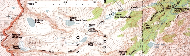
At the ranger station I was told that I might be able to see Mt. Whitney from Upper Boy Scout Lake. There is no proper trail, but I should be able to follow a path to it as it was up along the North Fork of Lone Pine Creek. Being only about two miles from the Portal, and thinking it was within my ability, I initially planed on going to Upper Boy Scout Lake. (see on map above)
I finally started on the hike with guidance and enthusiasm at 1030. I thought that I'd follow the Mt. Whitney trail to my turning point at the creek, and then just follow the creek to the lake.
Guidance and enthusiasm waned real fast as I lost the trail in all of about 20 steps. I couldn't believe that in a blink of an eye it was gone (I still can't believe it). But with a map and compass available I began a little Terrain Following Navigation; off I went in search of the trail.
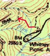
As noted in the above map, my errant course (in red) consisted of crossing a little creek, and heading up the hill. I mean UP. Ok, I am a healthy Marine (retired), so a little climb should be no major undertaking. It was not a major undertaking, monumental is a word that better describes it! I cannot say when the thought of foolishness came into my head, it had to have been while on hands and knees inching my way up the hill, "off the trail" as it was. This was not an ideal way to start a climb, as way too much time and energy was wasted. Upon finally discovering the trail, it was time to sit back, regroup and reorganize. Plan B was activated. Lone Pine Lake was the new destination because it was closer, and on the established trail.
The "Established" Trail is found.
(After about 300 foot of climbing up the face of the hill. I know that was a
dumb climb.)
Thus the trek to Lone Pine Lake commenced. Well wouldn't you know it, after just a few steps along the Trail I happened upon... none other than the North Fork of Lone Pine Creek. This was somewhat encouraging....
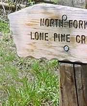
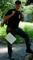
... somewhat encouraging, but not enough to change the destination. I was now about an hour into the hike, and I was exhausted. Finding this sign did not raise my spirits at first. But the creek did, as there was a small, but pretty waterfall that greeted me. There was a little pool under the fall, and I thought that if I was going to get any pictures of me in the water today, I had better get them now ! So I stopped, set up the tripod, got into my formal FEOR dive gear and took a little dip in the pond under the waterfall at the North Fork of the Lone pine Creek. Picture below.
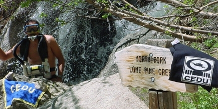
First "dive" of the day.
That "dip" was the best thing I could have done. I got my
photographic evidence, but more importantly I cooled down, got refreshed, and
felt much better about continuing the trek up the hill.
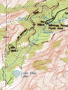
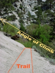
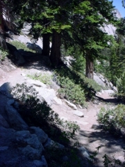
The trek continued after reconfiguring the Mod 1Mark 0 ( backpack) for travel. Shortly after continuing the hike I was introduced to what is called the "switchback". As indicated on the map (above) the switchback(s) are a zig-zag route up the hill. What is not indicated on the map is the number (quantity) of switchbacks that are about to be encountered. I swear there must have been over a hundred switchbacks to go up. (I was getting dizzy.)
One of many, many, many switchbacks.
(Notice the slope of the hill.)
Each switchback seemed to be about a hundred steps wide, and there was usually a nice rock to sit or lean on at the end of each one. (Wonder how that happened?) The view of course was wonderful.
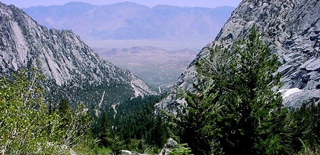
View looking down the valley.
The brief rest that was frequently taken was most likely the result of both, (1) not having any prior conditioning for this kind of activity, and (2) the lower partial pressure of oxygen that was being breathed up here in the nine to ten thousand foot elevation range. (At the lake a reading of 0.15 partial pressure was displayed.) This lower partial pressure of oxygen had an effect on me in reducing the amount of reserve energy I experienced. Muscles were not really sore, nor did I think my cardiovascular system was over stressed, it was just that after about a hundred steps or so I felt physically weak and wanted to stop for a little rest of a minute or so. Each step taken is a climbing step, and it did seem to drain some energy reserve. (Of course I might have also been experiencing a bit of dehydration. Not having as much water as was really necessary, I was only taking small sips in order to make the 22 ounces last the trip up.) I didn't want to get into a position of exertion, so I just took it slow and stopped frequently. (Measured heart rate never exceeded 120.)
At about the last switchback that was now leading me away from the nice view of the valley I checked my clock. It was 1300, two and a half hours of fun and no sign of the destination. I considered calling it a day at this point, because I did not know if I would ever find the lake with enough time to "play" and return down the hill at a reasonable hour. (Didn't want to be up there at sunset.) All of a sudden a hiker appeared from above. I asked him how far it was to Lone Pine Lake. He said I have made it about four-fifths the way there, and it should take me less than a half hour to get there. That was the encouragement I needed. With a newfound second wind I was off to the Lake.
And low and behold, I saw a sign....
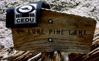
...
and immediately marked it.
Lone Pine Lake was within my grasp. Just a little jaunt across a stream and through some woods, which were nicely marked, and lo and behold there it was.
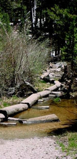
Over the river and through the woods. (Nicely marked woods is the trail.)
A beautiful lake greeted me.
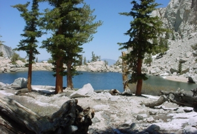
Lone Pine Lake
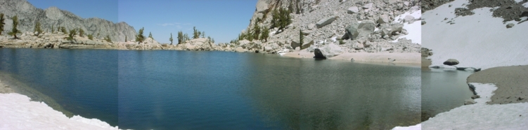
Panorama of the lake.
Arrival time was 1330. After a few moments of enjoying the view, a field expedient camp was made. Coordinates and elevation was recorded from the GPS. PPO2 of 0.15 was recorded from my FEOR HDD, and the tripod was set up. Dive gear was readied and I downed my shortie wetsuit.
If you have ever used the timer for your camera on a tripod to set up and take pictures you can imagine the scenes which followed (with some humor). After a while another couple of hikers came to the lake,and they offered to help by taking some pictures for me. As it turned out, either strange fingers were over the lens, or the camera battery died, or who knows what, but no picture of me in the middle of the lake was recorded. And that's the way it is. I actually dived the rebreather first, then went for a swim. If you listen real close to the picture of me holding the CEDU flag (photo previous page), you may hear my teeth chattering. (Did I say the lake was cold? Next time a full 1/8" suit will be used. And hey, I may even bring a hood!)
After diving for about 10 minutes, and not really deeper than 10 feet I was ready to do a little swim. As mentioned, the visibility was not great. There were some small six inch fish and a lot of rocks on the bottom. I was getting cold and thought a little swim would warm me up. Removing the FEOR I dived into the lake, and made it about half way across when my calves cramped up, damn! That did not feel too great. I turned around and returned to where I started. Wearing the shortie was a good idea(at least I'd be a floater for the recovery team), but racing across the lake was not. This was not the time to have an accident, as the hikers who tried to help with some pictures had left. Didn't want to press my luck now. So the pool party was over and I repackaged the Mk 1 Mod 0 Backpack for the trip down.
The hike down was uneventful. I left the lake at 1400 and arrived back at the car by 1540. I spent thirty minutes at Lone Pine Lake, and it took only an hour and forty minutes to walk down. (Only rested a couple of times on the way down.) Re-hydration was the first order of business upon leaving the mountain.
Departed the Whitney Portal at 1600 and arrived back home by 2015. It was a good day.
Equipment
 .....
..... 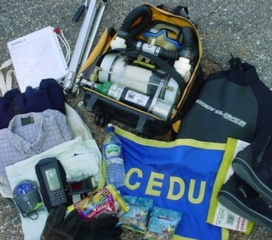
Equipment:
On my body:
Hat, glasses, CEDU Shirt, flannel lined pants, belt,
Speedo bathing suit, socks, boots, watch. ( 9
pounds)
Items carried on backpack:
(35 pounds additional weight)
Navigation: GPS, Compass, Map
Food: Trail mix x2, Beef Jerky, Water one 23oz bottle.
Clothing: Long sleeve shirt, polartec shirt, gloves, towel.
Dive Gear: Mask, Booties, Shortie Suit, FEOR Light, w/180 l tank and
PPO2 display, no weights.
Other: Tripod, digital camera, CEDU Flag, determination.
Lessons learned.
1. More water, more water, more water. Lets face it, for a day hike I'm not going to starve, but hiking out in the sun will sure contribute to dehydration. Future planning will include a bottle of water per hour of estimated time in daylight. (For planning will use an 8 hour day, thus next time bring at least 8 bottles of water.)
2. Really didn't need a compass. Just keep to the trails. (And if I do need a compass I'll get a small one. The boat's new compass will by then be bolted to the boat.)
3. For this kind of day hike clothing should consist of (1) wide brim hat, (2) CEDU T-shirt, (3) light long sleeve shirt, (4) those light pants with the legs that can zip off and make into shorts.
4. Bring an experienced photographer.
5. Do it again. Do it higher, deeper, and more often next time.
See you on the hill.
Smile,
Bob
Some Data:
Mount Whitney 36.579 N 118.293 W Elevation 14,494' (from
chart)
Whitney Portal 36.35.16 N 118.14.46 W Elevation 8,400'
(approximately)
Lone Pine Lake 36.34.55 N 118.14.91 W Elevation 10,075 (from
GPS) PPO2 0.15
Vertical Rate of Climb: ~1,600 feet / 3 hours
Drive distance: ~ 208 miles each way
Training: None
Body Wt: 175 pounds
Back Pack Wt: 35 pounds
Clothing Wt: 9 pounds
% Body Wt. Carried: 44/175 = .25 (25%), or 35/175= .20 (20% not counting
clothing)
Convert Meters to Feet, Multiply Meters by 3.281 to get Feet
Contour lines on maps shown: Heavy Lines 100 meters, Light Lines 20
meters
Links:
Topozone Topographic Maps
Terraserver Satellite
Photographs