Crestline Experimental Dive Unit
Presents
Diving Mount Whitney, Part III
Ascent To The Summit or Mt. Whitney in a Day
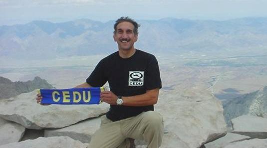
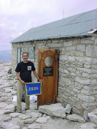
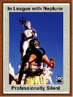
Dr. Bob Proudly showing the CEDU colors at the Summit
of Mount Whitney 27 July 2003
That's right, 14,496.811 feet. (It took me 9 hours to make the hike up from the Whitney
Portal.)
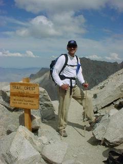
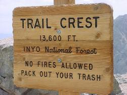
A milestone, the Trail Crest, 13,600 feet.
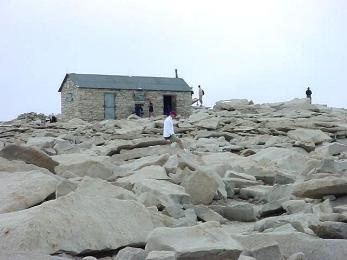
The lightning shelter at the Whitney Summit. (I thought I would never see it.)
CEDU has Arrived. Within minutes the sky turned black. It started
to rain, got cold, and then the rain turned to hailstones about the size
of BB's. I did not hang around, but left the summit
in a hurry. The trip down took 6 hours, 20 minutes. Four hours later I was back home, then back to work
the next day.
Smile, & Hope to see you on the hill next time. -Bob
Now to elaborate on the story....
Knowing that my friend Erick has a "Technical" climb looming over my head
later this season, a continuation of my training program is in order.
In order to experience and "acclimate" to the high altitude alpine
environment, I thought it would be beneficial to do a day hike to
the top of Mt. Whitney before I even thought to doing a multiple day, off
trail, technical attempt to the summit. So, the next step of my conditioning
was to hike to Whitney's summit. (Erick had made it very clear to
me that he was not interested in "just walking up to the summit"
because he has done that before, thus I was on my own.)
In trying to keep up with this two to three week cycle up on the hill,
Monday the 21st I checked the Day permit availability on the internet (see
link below) for a permit on Friday. One was available, so I considered
a solo climb on that day. On Tuesday I called for the permit, but
discovered that the permit was no longer available. (They go fast.)
A permit was available for that Sunday, ... so I grabbed it.
The plan was to drive up the evening prior, do the "Whitney in a Day" hike,
and return home late that night. Without any elaborate melodrama
or theatrical embellishments, that is exactly what was accomplished.
It was a well thought out, researched, properly outfitted, and successfully
accomplished mission. Equipment obtained was exactly that which was
needed and used. No accidents or other unforseen events occurred.
And I was back to work the next day cheerfully performing my dental arts,
and telling my patients all about the hike to Whitney.
Outfitting consisted of printing out new Topographical maps (from Topozone.com),
and the purchase of a Camelback pack. (I picked up a PeakBagger for $100
at the Chapparral the day before the hike. This Camelback has a 100
ounce water bag, a little pack and a waist strap with a little padding.
It work just fine for this day hike, but for more weight, or multiple day
hiking a back pack with a better padded waist band would be more desirable.)
I packed the back pack with what I considered essential gear, and successfully
got everything I needed into it. In the attempt to keep weight
down I reviewed the suitability of every item In reevaluating each
item some were eliminated, and some were switched to smaller quantities
and/or lighter items. Changes such as using a lighter belt,
less snack food, smaller flashlight, smaller knife, smaller caliber firearm,
etc. lightened the load. And lastly at the Whitney Portal parking
lot, deciding Not to bring the FEOR Rebreather was my final, last
minute, very difficult, yet very smart decision which contributed
markedly to weight reduction. . I ended up carrying a light
25 pound pack, with less than three pounds of what some may call
"nonessential toys". All clothes and all gear was used at least
once on the hike. ( And no item was used in anger.)
A well maintained trail all the way to the summit exists. [Which no doubt
is a story all to itself.] A section of trail up on the
Trail Crest was hard on the ankles because it was composed
entirely of small rocks. But overall the hike up to Whitney was straight
forward with no surprises. I would like to say that you cannot get
lost on your way up, but believe it or not some faster hikers passed me
more than once. I couldn't figure out how that could happen till
I asked. I found out that these fast walkers speeded right off the
trail and got lost. They turned around when they realized their error,
and thus had another opportunity to fly by me again. (and again in some
cases....). Looking where you are going helps.
Walking "uphill" for nine hours is not a task to be discounted, it was
work. Thoughts of running up and down the Science Building
at college with forty pounds of sandbags around the neck was revisited
as I thought of how Bill Jergens, my college Crew coach prepared me for
this day. Those seven story Science Building runs was his version
of "running stadiums" for the crew teams fitness training.
I guess some training does last a lifetime.
Altitude of course, does have its effect. Any reserve energy
you thought you may have possessed is somehow gone. This
fatigue would be the only sign of Altitude sickness I could
identify experiencing. (Hallucinations and thoughts of grandeur
of
summit conquest, would have to be classified as a pre-existing
condition, and not a result of the altitude. My wife can confirm
that observation.)
The ascent would have been much more enjoyable if stretched over
a couple of days. A continuous walk with no break really distracts
from fully enjoying the environment. An eleven mile hike for nine hours
constantly going up six thousand feet is not exactly a fun walk in the
woods. Most of the time was spent looking at the trail ahead
of your next step in order to assure a secure footing. You really
don't want to trip and fall on this hike. (The least of your problems would
be a 11 mile hike down with a sprained ankle.) As far as
"woods" is concerned, the hike will take you above, and out of the
tree line smack into the landscape of the Moon!
What I thought was the most spectacular part of the hike was not actually
being on the summit of Whitney, which was the object of the mission, but
standing at those "windows" on either side of Keeler Needle, the
sharp peak just before you reach Whitney's summit. At these
two locations the trail is little more than shoulder width wide,
and there is a rock face immediately ahead and behind you.
Leaning slightly to the left or to the right places your head over the
edge of the trail and gives you an unobstructed view almost straight down
for more than a thousand feet on either side. (Be prepared for some
wind, and Don't fall.) Neither pictures or the word "breathtaking"
describes the remarkable view, or the magnificent feeling this visual provides.
Being at those two spots on the trail was the E ticket for me. Arriving
at the Summit was merely the frosting on the cake.
It is a long hike, but finally the summit comes in view, and eventually
is reached. Mission accomplished. The obligatory
summit register is signed, (though I never found out who keeps the log).
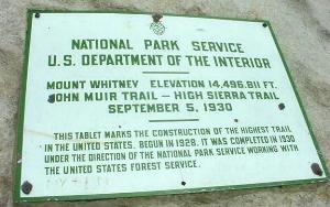
Then there are the obligatory pictures of the stone shelter, plaque, benchmark
and yourself at the top of the highest mountain in the continental US.
You rest a little and begin to take in the grandeur of the view,
your personal accomplishment, and the accomplishment of those who actually
made the trail to this summit. What a feat that was. (Thank
you all.)
The few minutes used satisfying the above photographic and spiritual
requirements was cut short as a dark cloud came over the summit.
Yes, one of those afternoon thunderclouds Whitney is noted for came
through as advertised. In a matter of minutes it got dark,
started to rain, than it got very cold and the rain turned to BB
sized hail. Time to leave.
My gear
was packed, and I was on my way out of there before that brief weather
phenomena passed. It was more entertaining than threatening,
but I didn't really want to be up there if lightning decided to strike.
It doesn't take you too long to realize that there is still another
major hike back facing you. There is little consolation in knowing
that the trip back is all down hill. The dip between Trail
Crest and the Summit is Whitney's dirty little tick. At this point
you are tired, fatigued, breathing thin air and smack up against another
up Uphill to Climb. (Where did the easy downhill walk go.)
Somehow knowing that the overall trip back will take a couple of hours
less doesn't make you feel any better at that point. No matter
which way you look at it, it is still another 11 more miles to the car.
From Trail Crest it now truly becomes a down hill path to the Portal.
I was pretty tired at this point and was glad to join up with a group that
had a brisk pace down. I was able to keep up with and followed them
all the way down to Outpost Camp stopping very few times. It
is amazing how pleasant the trip back became after descending in altitude
a little, and regaining enough energy to engaging in conversation.
(There were people from many different countries, and all the people I
met on the trail were very nice. Even the Rangers, I met two, one
just outside Lone Pine lake checking Permits, and one on the way down from
Trail Crest. This second Ranger had her dog, a black Lab, with her.)
Whitney Portal was finally reached before dark. Of course a commemorative
"I Climbed Mt. Whitney" hat was purchased from the Portal Store.
I did not hang around long, but bid my au revoir to the mountain and headed
home.
As mentioned above, my "dental Disneyland" called, and I was back to work
the next day. Dare I say that my patients appreciated the additional
anesthetic effect my "I climbed Mt. Whitney in a Day" story telling had
on them (during a root canal). Guess you would have to
be there.
In all it was a great day, and I am ready for the next step.... wherever
the trail may lead me.
Smile, Bob
Some Information about Altitude Sickness...
Altitude Sickness: Everyone is affected by the reduced partial pressure of oxygen experienced
at elevation to different degrees. People with pre existing medical
conditions of a cardiovascular nature should consult a physician before
attempting this climb.
High altitude Pulmonary Edema (HAPES) This form of altitude sickness affects the lungs.
Symptoms include:
Severe, persistent cough
Rapid Pulse
Rapid Breathing
Confusion, delirium, irrational behavior
Gurgling chest sounds
High Altitude Cerebral Edema (HACES) Usually occurs when someone spends days above 12,000 feet. Symptoms
include all the above symptoms of AMS and HAPES in addition to Ataxia (loss
of coordination). Treatment for HAPES and HACES is descend to a lower
altitude by at least 2000 to 3000 feet and seek medical assistance.
Equipment Carried & Used
Wear: hat, sun glasses, CEDU T-shirt, pants, uw, socks x2, newbalance
745 shoes, watch
Clothes: long sleeve T-shirt, polartech pullover, hooded sweatshirt
Speedo bathing suit, towel, swim goggles/case (for those opportunistic
swims)
Walking stick/tripod (homebuilt of 1/2 " wood dowels)
Camelback/100 ounce water, 46 oz Gatoraid, trail mix, jerky, nuts,
lifesavers (butterscotch)
Flashlight x2, batteries AA x4, AAA x4, rope, plastic bags, TP, wire
tie, electrical tape, eyeglass
Camera, GPS, compass, Topographical map, notepad, pens/pencil, enthusiastic
attitude.
148 ounces water & some snack food.
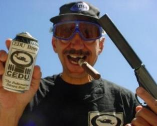
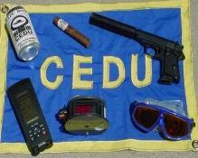
A can of CEDU Brew, Cigar / matches & Walther.
26 July 2003 Saturday 1030 Depart Crestline
(4,750) PPO2
0.18
27 July 2003 Sunday 0249 Arrive Whitney Portal
(8,360) PPO2
0.16
0400 Start Ascent to Whitney
0545 Pass Lone Pine Lake
(10,000) PPO2
0.15
1030 Arrive Trail Crest
(13,600) PPO2
0.13
1315 Arrive
Summit
(14,496) PPO2
0.12
1330 Leave Summit
1950 Arrive back down to Whitney
Portal
2010 Depart Whitney Portal for
home
28 July 2003 Monday 0005 Return Home to Crestline
It is interesting to see the variation in the vertical
rate of climb accomplished on these three ascents. The first trip
with 40 pounds took three hours. The second trip took an hour more
to get up to Lone Pine lake. That trip had a greater amount of back
pack weight, but I felt much better on that hike up. It was not the
additional weight which slowed down the ascent, but the additional people
in the party which made the climb up more timely. (More people in
a group slows down the entire group. Whether it be stopping for pictures,
breaks, or to enjoy the scenery, more people in the group equaled more
stops overall on the way up.) The last trip to the Summit resulted
in a climb which exceeded both previous climbs, either on the leg to Lone
Pine lake, or overall to the Summit.
Consumables Water : drank 100 ounces
Gatorade: drank 40 ounces, returned with 8 ounces
Food: about 10 ounces of
snack food was consumed (trail type mix)
Future Plans: Who knows what tomorrow will bring, there
is The Mountaineer's Route to summit (rated rated Class 3),
The East Face to summit (rated to Class 5.6), The East Buttress to
summit (few short sections of Class 5.7 and 5.8) and many other climbs
available. (Future climbing is only limited to how extensive my interest
in climbing becomes, or orders received from higher authority.)
(Now a word from our sponsor.)
The CEDU Brewing Company, Inc. proudly announces that the...
CEDU Alpine Operations Group is now a member of the Mt. Whitney Swim and Dive Team
When you reach the Top of the World, It's time to Relax with an Ice Cold CEDU Brew, A quality Cubana, and your partner Walther. (No need to shout it out, Silence is Golden!)
This CEDU operation has been ATF Approved
I cannot call my climb to
Whitney's summit as the shot heard round the world. In actuality this mission
had a silent celebration. As "Professionally Silent"
as all rebreathers and other items manufactured by the CEDU can be. -Smile, and hope to see you
on the Hill. -Bob Director, CEDU
To Swim is Human, To Dive is SUBLIME, To Suck Thine Own Bubbles is Extreme, To Climb, Swim, & Dive Mt. Whitney is just one more little Membership requirement of
the CEDU.
Disclaimer: No animals were injured in the creation of this webpage.
No shots were fired in anger. All homebuilt items functioned as designed.
All film props look really good. I took only pictures, and
left only "clear and copious" liquid body wastes on the mountainside,
and away from streams. No fires were set, and all solid trash
was hauled down the hill, ... except for a grand offering of high
quality personal fecal matter which was deposited into the solar toilet
at Trail Camp. Thank you.
All Pictures and story Copyright Robert Iannello 2003.
(As always screenplay rights available.)